Showing posts with label soil. Show all posts

Monday, January 30, 2012

White Tank Mountains Bajada Trail Nature Hike


In our last post we discussed hiking the South Trail in the White Tank Mountains.  Now we'll move on toward a short section of the Goat Camp Trail and finally onto the Bajada Trail.  The end of South Trail and this section of Goat Camp Trail is quite interesting for those who like to examine landscape patterns...

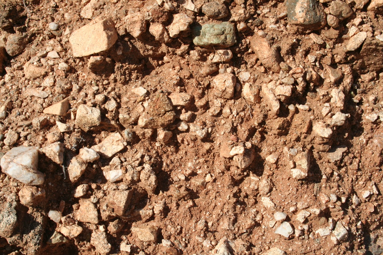
Most of the South Trail is rather straight and smooth, but close to Goat Camp Trail is sort of dips down a little and you will notice the surface becoming a lot more rocky and rugged.  This is the second alluvial fan in the bajada.  Typically this type of surface is closer to the mountain then the previous surface we discussed, so this bajada is sort of upside down.  I suspect this odd configuration of alluvial fans is a result of this second alluvial fan resulting from a large avalanche or debris flow that came out of Goat Camp Canyon.  The abundance of disorganized rocks and rugged surface could be in indication of an ancient avalanche.  The dry wash at the beginning of the trail also is responsible for eroding away the smaller sediments and leaving behind the heavier rocks and a rugged surface.  The major plant cover is brittle bush which prefers rocky and often unstable soil surfaces such as this one.  Palo verde and jojoba also seem to like these soil conditions.  There are also a decent number of cacti present and a few bursage in patches, indicating there is likely some caliche in the soil. 
This rocky and rugged soil alluvial fan surface is more typical higher upslope.
After hiking through the rocky and rugged area and heading uphill slightly on the Bajada Trail from Goat Camp Trail, the trail returns to the same alluvial fan most of the South Trail covered.  So same soil conditions and same plants as most of the South Trail.  But here I want to point out the abundance of saguaro cacti, the icon of the Sonoran Desert.  Saguaros are more abundant here than just about any other area west of Phoenix.  The reason for this is, as mentioned before, the soil conditions and abundance of triangle-leaf bursage.  In addition to that, this area receives about nine inches of rain annually and is relatively free of freezing temperatures.  In areas east and north of Phoenix there are many populations of saguaros that are denser, as a result of greater rainfall, upwards to about 12 inches annually.  These higher rainfall areas are also higher elevation and therefore more prone to freezing which can damage saguaros by causing their arms to droop towards the ground.  Very few saguaros in this area have drooping arms in the area of these trails due to the lack of freezing temperatures.  There are a few though.  Nearly all of the Saguaros in this area are mid to older aged, you can tell the age of a saguaro simply by its height and presence of arms.  The taller a saguaro is the older it is, and more arms usually indicates older age also.  There are not a lot of young saguaros, which tells us there isn’t much reproduction going on, and if reproduction doesn’t increase in the next 50 or so years the population will decrease significantly.  There is also a lack of very old cacti, which indicates that the population of saguaros was once much smaller than it is now.  While I suspect the saguaro population may be decreasing due to lower rainfall during the past two decades, a few years of good rain could easily allow for the establishment of many young saguaros and cause the population to bounce back.  So there is no immediate reason for us to fear the disappearance of the saguaro from the White Tank Mountains during our life time.
A saguaro cactus with a drooping arm.  Typically, arms drooping down like this means the cactus was damaged by freezing temperatures. 
And this concluded the White Tank Mountains South to Goat Camp to Bajada Trails tour.  Hopefully it was interesting or helpful, even if you don’t hike these trails yourself.  In my 150 mile hiking goal for 2012 I currently am at 15 miles.  I have a few trails I have hiked and have yet to write about and you’ll be seeing them in the near future.  Also, if you have any questions about anything pertaining to this post, or any post, let me know.  I want to make everything here on Practical Biology of course practical, interesting, and educational.  Thanks!
A crested saguaro cactus along Bajada Trail.

Friday, January 27, 2012

White Tank Mountains South Trail Nature Hike

Two Saguaro cacti in the White Tank Mountains Regional Park.
When it comes to viewing Saguaro Cacti and an unusual bajada or alluvial fan formations, the South and Bajada Trails in the White Tank Mountains  are about as easy and as they come, at least for the western portion of Phoenix, Arizona.  The trail begins at the South Trail near the entrance of the regional park, heading towards a short section of Goat Camp trail, and then to the Bajada trail, entire length about 3.5 miles and all pretty flat for some relaxed hiking.  The entire length of trail transects the bajadas, or alluvial fans, that were deposited by ancient erosion and avalanches descending from the surrounding mountainsides to the north and south of the trails and Goat Camp Canyon to the west of the trails.  Different types of deposits and differing types of drainage patterns has resulted in two major alluvial fans forming a bajada that is seemingly backwards in formation.  One of these alluvial fans though is ideal habitat for the iconic Saguaro Cacti as I will explain below.  This post will be in two parts, this first post will cover mainly South Trail.  The second post on Monday will cover mainly Bajada Trail. 
Desert dry wash along the South-Goat Camp-Bajada Trails in the White Tank Mountains.
Beginning at the South Trail trailhead near the entrance to the park, you immediately hike down into a dry wash.  This wash is one of at least a few washes that are responsible for the unusual bajada formation along the trail further along.  As most people would expect, a dry wash, also known as an ephemeral drainage, is where runoff water concentrates and flows for short periods of time following heavy rainfall.  The water only flows a short period of time because it is quickly absorbed into the loose sand in the channel where it can infiltrate very deep.  Deep in these wash sediments the water is protected from the extreme heat on the surface and is therefore a reservoir during long dry periods.  Only deep rooted plants, however, can access these reservoirs and that is why there is a concentration of ironwood and palo verde trees.  Even shallow rooted plants such as cacti and triangle-leaf bursage are in higher concentration here through, simply because there is more moisture in these washes then the surrounding soils.  Along with transporting water, washes similar to this one also transport sediments eroded from further upslope.  Washes, as they transport sediments down slope, are the major creators of alluvial fans.  Many alluvial fans were once at the end of a dry wash where the wash sort of spewed out over the surface all the sediments it transported from upslope during short periods of water flow.  Washes also are the major destroyers of alluvial fans being they erode into and carry away the sediments that compose the fans.  Because of these things, if you are familiar with the washes on a Sonoran Desert alluvial fan or bajada you can know a lot about the history of these landforms.  We will see this later on in the hike towards the end of the South Trail.
The plant community along the South Trail is mainly Cacti, Bursage, and some Palo Verde. 
Once hiking out of the wash the trail crosses onto another alluvial fan surface with a different soil type.  This soil type continues for most of South Trail.  The vegetation is characterized by shallow rooted plants, mainly cacti and triangle-leaf bursage.  This tell me that the soil is well developed, probably with a caliche horizon and maybe with a weak argillic.  Caliche is simply a rock-like calcium layer that forms about 20 inches below the soil surface in deserts and argillic horizons are deposits of clay just above the caliche.  Both layers prevent deep roots from penetrating and help shallow rooted plants become established, the most important of which is triangle-leaf bursage.  This small shrub grows everywhere along most of South and Bajada Trails and because of its abundance there is also an abundance of cacti.  Bursage functions as a nurse plant for many desert plants.  Odd as it might sound, most desert conditions are too hot, dry, and sunny for most desert plants to establish themselves without the aid of another plant.  Being bursage can establish without help of other plants, it provides the shade and slightly cooler and moister conditions required for cacti to germinate and grow under their small canopy.  The presence of bursage, along with the soil conditions, is therefore why there are so many cacti present along the South and Bajada Trails.
 To be continued Monday...

Monday, January 16, 2012

Biology with a Birds-Eye View: From an Airplane Window or Google Earth


One of the last places you would expect to do biology is on an airplane.  As long as you have a window seat however, and can look at the ground you can make some pretty interesting biological observations.  For that matter, you really don’t need an airplane you could simply use Google Earth to make the same observations.  Google Earth is of course the easier and better option of the two though, but either way you can look at the ground and find out some pretty interesting things.  A birds-eye view of the ground can tell you about soils, vegetation, landforms, landscape patterns, and simply be interesting to explore.  In some of my scientific investigations I have spent a lot of time examining Google Earth images looking for vegetation, soil, land form, and land use patterns.  Aerial images truly can be a joy to search through and can yield all kinds of interesting pieces of information.  

Here are some of the things you can discover about the landscape with an aerial photograph:

Land forms: Is the landscape hilly, mountainous, flat, marshy?  Often Google Earths 3-D landscape feature will help with this.

Vegetation: Forest, grassland, desert, agriculture, swamps and all their variations can be identified with aerial photos.  

Soil: Identifying soil is difficult when lots of vegetation is covering the ground.  However, in areas of sparse vegetation such as in deserts or where agricultural fields have been cleared you will be able to identify soil color.  These colors can tell you something about how the soils developed.  Also look for changes in color in the soil across the landscape, often you will be able to identify vegetation changes that go along with soil changes.  

Drainage patterns and waterways: It can be very interesting to see how exactly water moves or drains across the landscape and how this relates to soil color where visible and to vegetation patterns.  It can also be fun to trace a waterway back to its source.

Look for other things also such as abandoned mines, farms, secluded streams, or anything else of interest.  I have searched Google Earth images for hiking trails, specific types of landforms, canyons, rock formations, and anything else of interest I come across.  I have also enjoyed tracing the path of a waterway to see how it changes with distance.  Sometimes, after exploring these aerial images you can then hike or drive through the area you explored, make sure you have legal access to the land before entering the land however.  Also, be extremely careful searching for old mines or farms which can be extremely dangerous.  Obviously you could fall into an old mine and old farms often have unmarked wells.

Friday, January 13, 2012

Black Rock Trail White Tank Mountains: Touring a Bajada

Lower alluvial fan, furthest away from the mountains, of the bajada on Black Rock Trail in the White Tank Mountains.  Cacti and bursage, shallow rooted plants characterize this part of the bajada indicating some caliche development in the soil.  Creosote, a deeply rooted plant shows that this caliche is not well developed and still allows for deep roots to penetrate it.

As for easily accessible trails, the Black Rock trail in the White Tank Mountains Park is a good one.  Crowded, but not as crowded as the nearby Waterfall Trail and the landscape is not nearly as trampled.  This particular trail has two loops, a short loop with a smooth and wide path, and a long loop which is narrower and slightly rocky.  The short loop is half a mile while the long loop which branches off and returns to the small loop is 1.3 miles.  While most hikers may find such a short and easily accessible hike sort of boring, I believe a little scientific knowledge of the area can give you some things to look for, making the hike quite interesting.  I personally would have considered this hike sort of boring if I wasn’t taking the time to examine landscape features.  But taking a little time to smell the roses, or rather examine the dirt, rocks, plants and so on, can make this boring hike quite interesting.  Looking closely, this loop is an excellent example of a classic Sonoran Desert bajada, specifically the upper to mid portions of a bajada.
First of all, a bajada is simply an aggregation of several alluvial fans.  And if you are wondering what an alluvial fan is, it is simply the sediments or dirt that is deposited on the ground by water.   Alluvial fans often make a fan-shaped landform when viewed from the air.  Alluvial fans are deposited adjacent to mountains when sediments wash off the mountain.  Several alluvial fans deposited in succession together form a bajada, and in the Sonoran Desert the further a fan is away from a mountain the younger it is.  The Black Rock Trail has a slight slope up towards the mountains.  Hiking along this slope you are hiking over very old alluvial fans which sediments were once part of the White Tank Mountains.

In the case of Black Rock Trail, there are three alluvial fans, each with is distinct soil type.  Starting off at the trail head, furthest away from the mountain is the youngest fan.  The plants indicate there is a weakly formed layer of caliche here.  Creosote is most common in this area of the trail being its deep roots do not tolerate well developed caliche layers, and therefore indicates weak caliche or an absence of it.  Triangle-leaf bursage also common to the area however requires some caliche development in the soil.  So put together bursage and creosote indicate a weak caliche horizon. 
Middle alluvial fan on the Black Rock Trail.  Characterized by shallow rooted plants such as cacti and triangle leaf bursage.  The presence of caliche in the soil favors these shallow rooted plants.
Hiking up the slight incline a short distance there is an increase in cacti, bursage, and palo verde, and a sharp decrease in creosote.  Palo verde, bursage, and cacti all seem to prefer stronger caliche development while creosote doesn’t tolerate it well.  This is the second alluvial fan, and plants with shallow roots that can accumulate above the caliche dominate this area.  Deeper rooted plants such as creosote are not able to penetrate the caliche and therefore don’t grow in abundance.

If it were just for the bajada, this trail might be at least a little boring.  But in the beginning to mid portions of the trail you pass some striking out-crops of granite.  What is striking about these out-crops is not simply that they are granite, but rather that the rocks are out of place in the bajada and that their coloration is pitch black in places.  These out-crops are sort of islands of rock surrounded by the dirt and sediments that form the bajada they pierce through.  As the bajada sediments were deposited off of the mountain these rocks remained in place, largely unmoved.  The alluvial fans and bajada was simply deposited around the rocks.  The rock formations are therefore very old, much older than the surrounding bajada.  The old age of the rock formation is indicated by the presence of the thick and very dark black desert varnish layers that color these rocks.
Granite outcropping along the Black Rock Tail.
Hiking beyond the short loop and onto the long loop the trail becomes a little rougher.  You will notice that the ground becomes increasingly rocky and more uneven.  This indicated the transition to the third and oldest alluvial fan closest to the mountain.  Here, there still may be some triangle-leaf bursage indicating caliche, but the further you go there is defiantly a shift towards more brittle bush.  Brittle bush prefers very rocky and often unstable soil surfaces, both common to this area.  There are still on this third fan a lot of cacti as well as palo verde and some ironwood trees.  The Ironwood trees seem to increase the closer you get to the Waterfall Trail, possibly a result of their deep roots accessing water that sinks deep into the sediments after if flows over the waterfall.
The upper alluvial fan of the bajada.  If you were able to see the ground you would notice that it is much  rockier and rougher than the lower two alluvial fans.  This type of soil favors brittle bush which is the shrub layer you see covering the ground here.  Cacti are still common here indicating some caliche in the soil.
As the long loop of the Black Rock Trail loops back and starts heading away from the mountains you begin your return down the bajada.  The whole trip requires at most 45 minutes or so if you go slow, and in that short period of time you can get a great tour of a Sonoran Desert bajada and the plant ecology.  Really, tours of this type don’t get any easier.  After this hike I am at about six miles of my 150 mile hiking goal for 2012.  So far so good.  I am hoping to do some longer hikes in the near future and hopefully take some big chunks out of my goal pretty quickly.  

Tuesday, September 6, 2011

Sonoran Desert Soil Distributions

Dry mountain canyon wash looking out on the desert below.  Canyons such as this one are the gateways for nearly all soils in the Basin and Range.
When most people think of desert soils they think of rolling sand dunes.  The problem is that sand dunes are not soil at all, rather they are blowing, shifting piles of sediment.  And sand dunes are relatively rare in the Sonoran Desert anyway.  Instead of blowing sediments, the life of Sonoran Desert soils begins as rock in the scattered small mountain ranges common to the region.  A process called weathering breaks down this rock into smaller and smaller particles.  These particles then wash out of the mountain due to heavy rainfall causing erosion, debris flows, or flash floods.  Odd as it might sound, nearly all desert soils are built by these types of water movements through the landscape.  Contrary to intuition, the very rock and dirt fabric of the desert is carved out and formed by water.

Knowing the above process is essential to understanding soil distributions in the Sonoran Desert.  And knowing where soils are located is key to understanding the Sonoran Desert landscape.  Both hydrology and plant communities are strongly defined by the desert soil.  In a previous post on soil mapping we discussed generally how to locate soils in the landscape.  In this post we will discuss specifically how to locate soils in the Sonoran Desert.  Believe it or not, desert soils are complex in structure but relatively easy to map.  The general rules that we discussed before apply in a rather neat fashion.

The alluvial fan is circled in white in the below image.  The canyon through which all the sediments came from for the alluvial fan is lined with blue.
Sediments washed off a mountain are deposited in landforms called alluvial fans.  Deriving their name "alluvial" due to being water deposits, and "fan" from the fact that they are often fan shaped.  These fans are created through flash floods or debris flows which cascade sediments through mountain canyon washes to basins below.  Typically, once these flow reach the wash outlet, sediments are deposited radiating out from the outlet in a fan like shape.  Over long periods of time these fans can become quite large, often merging with other fans being deposited from other canyon washes nearby.  Then, from this first alluvial fan, sediments can be eroded off and deposited below forming a second alluvial fan.  This process of erosion and deposition can repeat itself several times and several alluvial fans can be deposited in succession away from the mountain range.  Each of these successive fans will produce a unique soil.  Erosion and deposition will often destroy the fan-like shape initially present when first deposited.
This diagram shows generally how alluvial fans, or soils, are arranged in a bajada.  Each soil  developed from an alluvial fan.  Each fan was deposited in succession outward from the mountain.  The oldest fan, or soil, being where it is labeled soil 1.  The youngest fan, or soil, is labeled soil 4.  Soil 1 and 2 are the oldest and in the Sonoran Desert are generally very similar with red soil, an argillic, and caliche horizons.  Soils 3 and 4 are also similar to each other and generally lack argillic and caliche horizons, also lacking red coloration.
The resulting succession of different alluvial fans radiating out from a mountain side is known as a bajada.  Each section of the bajada is a different alluvial fan with a different soil type.  These individual fans, or sections of the bajada, can be identified by basic soil mapping principals.  Each fan soil will have a particular soil color, horizons, a general rock type cover, slope, plant community, and landscape position.  Soils, or fans, closer to the mountain, higher up the bajada are much older.  Soils, or fans, further away from the mountain and lower on the bajada are much younger, in-fact they may have just recently been deposited.  The older a soil is the redder it will be (previous post on soil color), therefore upper bajada soils are red in coloration while younger lower bajada soils lack red coloration.  The red coloration indicates the presence of caliche and argillic soil horizons in most cases (previous post on desert soil horizons).  Upper bajadas will also have steeper slopes while lower bajadas will nearly be flat.  Upper bajadas will also generally have rockier soils and fewer rocks will be present lower in the bajada.

An upper bajada soil surface.  Cacti of several species, Palo Verde, Triangle-Leaf Bursage,  and some Creosote make up this upper bajada plant community.  These plants, except the Creosote, have generally shallow roots which are adapted to caliche and argillic soils common to upper bajadas such as this one.
Soils in the desert seem to have a particularly strong effect on plant life.  We will discuss this further in a future post but desert plants are a strong indicator of what lays below the surface.  Some plants prefer argillic and caliche horizons while others can stand them.  Generally shallow rooted plants such as Chollas, Prickly Pears, Saguaros, Triangle-leaf Bursage, and Foothills Palo Verde prefer caliche and argillic horizons in some circumstances.  Therefore shallow rooted plants prefer upper bajadas.  Creosote bush having deeper roots prefer the absence of caliche and argillics, therefore preferring lower bajadas.
A lower bajada soil surface.  This plant community is primarily Creosote.  There are a very few cacti also present though.  The deep roots of creosote prefer the absence of impeding caliche and argillic horizons upslope on the bajada.

Monday, August 22, 2011

How to Map Soils

Looking at this landscape a little knowledge of soils can explain a lot of things.  Learn how to piece together landscape stories with the information on soil distributions and mapping in this blog entry.
Unless you are a little unusual, you probably rarely consider the soil we walk across.  But its OK to be a little unusual, the benefits can be great.  If when we are hiking, or even in our own backyard, we were to consider the soil we stand on and how different types of soil are distributed around us, the education we would receive would be great.  Far to often even seasoned research scientists will forget about the soil they walk over, even if it makes a huge difference to what they are studying.  It would literally pay for these scientists to have a little soil education.  By using the clues outlined in this article you can begin to piece together where specific types of soils are located, and begin to develop a story to how the land, plants, and animals came into their present state.  This also helps in understanding gardening or landscaping projects.  Every landscape has a story to tell, and very often that story starts with the rocks and dirt.  Here are the clues to look for:

Parent Material
What is the general type of rock that you find in an area?  A good rock book will help you figure this out.  Certain rocks will produce certain soils (click here for a previous blog on this subject).  Fortunately, there are only a handful of different types of rocks most soils are made out of.  Where I live in the Arizona Sonoran Desert the most common rock parent materials are granite, gneiss, basalt, and schist.  Where I grew-up and still visit often in Iowa limestone and sandstone are the most common rocks.  In Iowa however, rocks are usually not present and the parent material is glacial deposits (glacial till), alluvial (water deposited along rivers or streams), or loess (wind deposited).  The lack of rocks also is a good indicator of a particular soil type.  If there are no rocks try to use landform or landscape position to identify soil.
An example of landforms in the Sonoran Desert.  The foreground of this picture is a flat basin with only 1 to 2% slope.  In the middle of the picture is a long narrow hill called a banali.  In the distance are mountains.  Each of these landforms will have their own soil types.   

Landform
What types of landforms are near you or are you on?  Hills, mountains, basins, plateaus, plains, depressions, small rises will all produce different soil types.


Landscape Position
Where in the landscape do you find yourself?  This is similar to landform but more specific to where you find yourself on a particular landform.  Do you find yourself on a hillside, a hilltop, a flat plain along a river, a mountain?  Are you close to a mountain or far away from a mountain?  All these different areas will have different soils.  Also consider elevation.  Are their multiple plains, or flat areas, each with different elevations?  Each individual plain will likely have different soils.

This granite rock and the lack of other rocks in the area indicates glacial till as the parent material.  This rock was carried by a glacier from Canada to Iowa during the ice age.  The landforms in this picture also indicate different soils.  The flat area in the mid to foreground are one type of soil and the hill in the background has a different type of soil.  Behind where this photo was taken is another flat area, lower in elevation and with finer textured soil along the Cedar River, indicates another soil type.  Difference in vegetation does not indicate different soil types in this picture due to different disturbance histories.  The grassy area is disturbed by burning every few years while the forest is not burned.  
Slope
What is the general slope of the landform you stand on?  Again, this overlaps with landscape positions and landform, but helps you narrow down a particular area to a particular soil type.  Is the slope steep, flat, moderate?  Approximately, what is the percent of slope?  Consider landform or landscape position again, hilltops will have one particular slope, hillsides another, and basins or plains another.  Each will have a different soil type.

Soil Color
What is the soil color?  Refer to this previous blog entry to find more about what that soil color means.  One particular soil is going to have one general soil color.

Soil Texture
What is the soil texture?  Refer to this previous blog entry to find out how to determine and what that soil texture means.  One particular soil type is going to have one general soil texture.

Plant Communities
Generally, plant communities correspond directly to soil types.  Meaning, two different soil types are going to have two different plant communities.  The differences in plant communities may not be obvious.  Also, if there is a history of disturbance using plant communities as an indicator for soil becomes worthless.  For example, using plant communities as an indicator in deserts works extremely well due to the fact that deserts usually lack fire or agricultural disturbance.  In the Midwest however, fire is a normal part of prairie management but not of forest management.  And depending on when agricultural or logging disturbances in the Midwest happened will also determine what stage of succession a forest is in.  So depending on when and what type of disturbance has happened historically, one particular soil type may have several different plant communities.

So piecing all these things together, you can determine that an area has one particular soil type if: 1. the area is on a particular landform, 2. the area is on one particular landscape position on that landform, 3. that area also has similar parent materials, 4. The area also has a general soil color, 5. the area also has a similar soil texture.  Lastly, plant communities may or may not indicate a soil, depending on disturbance history.

This may seem like a lot of information, but with some practice this becomes a lot easier.  Landscape stories can be quite fascinating and often, most of the information you need is right under your feet.

Friday, August 12, 2011

Soil Stories: Natural Resources Conservation Service

This 30 minute Soil Stories video from the Natural Resources Conservation Service is a great introduction to all the major aspects of soils.  I believe this video is valuable to just about anyone who is interested in soil such as hikers, gardeners, farmers, nature lovers, land owners, landscapers, and anyone who eats; so pretty much everyone.  Everything is presented in a very clear manor using real scientists and real scientific work.  Here it is:


We have been covering many of these aspects of soil in recent blog entries and this video sums them up pretty well.  I plan on covering a few more aspects of soil in the near future.  Then we will be moving on from soils to plants and animal ecology.

Tuesday, August 9, 2011

Cryptobiotic Crusts: What's a Biological Soil Crust?

The black stuff between the rocks is cryptobiotic soil crust, composed of cyanobacteria, algae, and fungi interwoven together.  If you look closely green may be also seen on the crust.  These green areas are the beginnings of moss growing on the crust, indicating a healthy crust that hasn't been disturbed for many decades or longer.  White Tank Mountains, west of Phoenix in the Sonoran Desert.
Cryptobiotic is sort of an obscure weird word.  Cryptobiotic soil crust probably is even weirder, like some odd disgusting thing nobody really wants anything to do with.  The reality is, these crusts are very useful and important to all desert life.  The very word "crypto" means obscure or hidden, and many desert hikers may have walked past miles of this crust without every noticing it.  "Biotic" means living, which is also odd being most of these crusts simply look like... well... crusts.  If we were to zoom in on these crusts with a microscope however we would find a complex interweaving of cyanobacteria, algae, and fungi.  This seemingly lowly inconspicuous  crust is essential to the desert, and without it desert life and landscapes can become much different.

For the majority of the year these crusty organisms are all dried out and dormant, appearing almost completely lifeless.  Even in this crunchy dry state cryptobiotic soil crust function in extremely crucial ways by covering the soil, thus preventing it from blowing away and also helping to retain water in the soil.  Given even a little rain however these crunchy crusts soften and become biological powerhouses.  As rain drops fall, the crusts protect the soil again by holding it in place, preventing erosion and therefore preserving the soil and landscape.  Infiltration of these raindrops is also facilitated so more water goes into the soil.  Lastly, cyanobacteria remove nitrogen into the air and fixes it into the soil, increasing soil nutrients.  So basically, these crusts protect the soil, increase and preserve soil water content, and enrich the soil with nutrients.
Cryptobiotic soil crust with pink lichens forming on the surface in the Sonoran Desert.
So why are all these function important?  Well, preserving the soil, increasing soil water content, and increasing soil nutrients all allow for more plants to be established.  Being deserts are in short supply of both water and nutrients even modest increases of these can have significant effects on the food chain.  When more plants are established the more animals an area can support.  More and healthier plants also means a healthier more stable habitat.  This is known as a bottom-up effect in ecosystems or food chains.  The bottom-up effect is when things at the bottom of the food chain, such as cryptobiotic soil crusts, have strong effects on organisms higher up the food chain.
Found at: http://www.soilcrust.org
Being these crusts have such a strong bottom-up effect, their destruction can have huge effects on entire landscapes.  Foot traffic, trampling by grazing animals, and off-road vehicles all can quickly destroy crusts that took anywhere from years to century's to form.  Grazing and off-road vehicles are especially destructive being these activities cover so much area so quickly.  Once a cryptobiotic soil crust is destroyed the soil becomes prone to erosion and there are less nutrients and water in the soil, harming the entire food chain.  So the best way to preserve these crusts is to limit grazing and keep all foot and vehicle traffic on the trail or road.
After disturbance, it can take anywhere from years to centuries for a crust to form again.  Deserts with summer rains, such as the Sonoran, form crusts more quickly in a matter of years to decades.  Cooler deserts with winter precipitation, such as the Great Basin, can take centuries to form crusts.  If a crust is undisturbed for very long periods of time mosses, liverworts, lichens and even ferns will colonize on top of the cyanobateria, algae, and fungi.  Protecting soil crusts is essential to maintaining healthy desert ecosystem function.

For a lot more great information check out: http://www.soilcrust.org
This website even has a great free downloadable field guide for soil crusts.

Sunday, August 7, 2011

Desert Pavement

This black rocky area is known as desert pavement.  Notice basically no plants grow in the desert pavement, instead growing in the gray/tan surface where the pavement is absent.  The interlocked rocks and dense soils of desert pavement prevent water from penetrating the soil, therefore preventing plant growth.
Traveling from east to west in the Sonoran Desert rainfall decreases from 12 inches annually near Tucson to the hyper-arid two to four inches of rain received along the Colorado river.  This results in extremely sparse vegetation across vast areas of the landscape within this hyper-arid region.  Often the desert ground appears as painted black over broad areas, forbidding nearly all life.  Taking a closer look at the black covered soil you would notice a network of black rocks that appear to have been puzzle pieced together.  These areas, have very hard ground not unlike pavement, which is in-fact where it derives the name desert pavement.  Walking across this pavement is quite easy being it is a relatively smooth, hard, and level surface.  Though easy to walk across, summertime on this pavement is quite forbidding with scorching sun and heat, being only a little better than walking across a blacktop parking lot.
Close up of some desert pavement.  Notice how the rocks are closely interconnected, often like a puzzle.  This results in rainwater not penetrating the soil and instead running off.  Plant and other live are nearly absent to areas like this.
When scientists initially found these vast areas of pavement more then 100 years ago they thought overgrazing by cattle had trampled and compacted the ground making it infertile and inhospitable to plant life. Later it was determined desert pavement was actually a natural phenomena, not caused by cattle grazing.  Over long periods of time, decades to millenniums, a desert soil surface has smaller soil particles like sand and clay either washed or blown away.  Heavier rocks stay in place becoming interlocked.  Most of these rocks are not normally black in coloration but over time become covered with desert varnish.  This varnish forms when magnesium and iron rich dust falls on the rocks staining them through the action of bacteria.  Both desert pavement and varnish are more common the drier a desert is.  This is why Tucson has far less desert pavement and varnish than areas around the Colorado River.  The more rain an area has, the more unstable the soil surface is.  Significant rainfall amounts result in rocks being washed away through erosion, preventing pavement and varnish from forming.

In our previous entry we discussed desert soil horizons, and if you were wondering, desert pavement is part of the A horizon.  Soil horizons are extremely important in determining where water accumulates and therefore where and what types of plants grow.  Desert pavement, as mentioned before, prevents water from penetrating deep into the soil due to its hard pavement like surface.  Typically, desert pavement also indicates underlying thick layers of caliche, both of which can strongly impede water and plant roots from penetrating.  Water may only penetrate a few centimeters deep, even after a good rain, and many years may pass between times where there is enough rainfall to penetrate to adequate depths to support plant life.  Outside of the pavement though water penetrates more often and a lot deeper as evidenced by obviously thicker vegetation. Every five or so years through there is significant rainfall to penetrate deeper into desert pavement soils and short lived flowers can color the normally black desert ground yellow.
Normally black and barren desert pavement covered with wildflowers after strong winter rainfall.  Picture from:http://www.desertmuseum.org/programs/flw_mohave.php

Saturday, August 6, 2011

Basic desert soil horizons

A dry wash that has cut into the soil creating a cut bank on the left of the picture.  The cut bank exposes caliche which is common to old desert soils. 
Walking over the surface of the land not many of us think much of what we are walking on.  Most people probably only think they are walking over a disorganized pile of dirt.  However, as we saw in our last entry, soils are a lot more complicated, containing organized O, A, B, and C soil horizons.  Odd as it might soils, soil is organized, and organization is exactly what differentiates a soil from a pile of disorganized dirt.  Dirt becomes a soil when the dirt becomes organized into horizons.  When initially dumped on the ground by a glacier, wind, water, or falling off the side of a cliff, dirt it is disorganized.  After siting for many hundreds to thousands of years horizons develop and the dirt becomes a soil.  Generally the longer the soil sits in place the more developed the soil horizons become.

Most people are very surprised to find out that deserts have soils.  Amazing but true.  In-fact deserts have some of the most organized and interesting soils in the world.  Being deserts lack rain and haven't been glaciated, their soils can range from very young to very old.  Other places further north that receive more rainfall and have been glaciated have much younger soils.  The wide range of ages in desert soil results in a wide range of soil types.  Deserts have the same O, A, B, and C horizons the rest of the world has.  However, they have some features that make them distinct from soils from other regions.  We will cover desert soils horizon by horizon.
The black and green stuff covering the ground between the rocks is a cryptobiotic soil crust.  This type of soil crust is common in desert areas that have not be disturbed.

O horizon:  Due to sparse vegetation O horizons are pretty much absent in any desert.  Any organic material that does fall to the ground seems to disintigrate into nothing over a very long period of time, resulting in no O horizon.  Wind does however cause dead leaves to accumulate under shrub and tree canopies, resulting in a very thin O horizon.  For this and other reasons, soils under tree and shrub canopies are richer than surrounding desert soils.  In many circumstances desert soils if left undisturbed for very long periods of time (years to decades to centuries) will form a living crust as an O horizon.  This living crust is called a cryptobiotic soil crust and is made of algae and fungi.  These microbes help water absorb into the soil, increase soil nutrients, and help retain soil moisture, all very similar to how other types of O horizons work.

A horizon: Nothing really special about the A horizon in deserts.  This horizon is usually the sandiest and often covered with a layer of rocks and or cryptobiotic soil crusts (the O horizon).  The rocks and soil crust both serve to slow water runoff, increasing water penetration into the soil.  Soil crusts also enrich the soil with nitrogen which aids plant growth.

B horizon:  This is where things get interesting.  Clay and calcium deposited by wind on soil surfaces is carried deeper into the soil by rain water.  Over thousands of years, clay accumulates into a dense and highly organized argillic horizon, generally one to two feet under the soil surface.  On the bottom side or just below, about two to three feet deep, calcium accumulates into caliche.  Caliche is a rock-like accumulation of calcium.  The older a soil is the large and more developed argillic and caliche horizons become.  These horizons prevent plant roots and water from penetrating, therefore also preventing the growth of deep rooted plants.  Many shallow rooted plants do take advantage of water that accumulates above these horizons, and will proliferate in these soils.

Caliche remains along a dry wash bank after the A, C, and parts of B horizon have been washed away by flash floods.
A relatively accurate way of knowing if a soil has developed caliche and or an argillic horizon without digging a hole, is to look at soil color.  Tan to grayish soils typically do not have caliche or an argillic.  Reddish brown soils will have caliche and probably an argillic.  Soils become increasingly red with age as more iron is deposited by dust fall.  Calcium and clay content also increases as a soil ages forming caliche and argillics.  So as a soil turns red, caliche and argillics also form.  The more red a soil, the stronger the caliche and or argillic horizons. 
Grayish-tan soil, indicating this soil does not have an argillic or caliche.
Reddish-brown soil, indicating this soil does have both an argillic and caliche.
C horizon: This is the originally disorganized pile of dirt, generally three or more feet under the surface.  Often, if you are digging, this layer can be quite difficult to get too if you have to dig through dense argillics and rock-like caliches.  Interestingly, nearly all desert C horizons are water deposited.  They were simply washed off a mountain or hillside, deposited, and then developed into the A and B horizons we discussed above.  Odd as it might sound, water is one of the most important soil forming factors in lands severely deficient in it.  In-fact, nearly the entire desert landscape is sculpted by water.

Friday, August 5, 2011

Basic soil horizons

This is the side of a hole dug into the dirt.  Notice the two different colors which indicated two soil horizons.  The dark soil on the surface is the A horizon, with the dark color indicating high organic content.  The lighter color is the B horizon, with the lighter color indicating low organic content. 
Have you ever noticed how soil changes in color or texture as you dig down-wards?  These differing layers of color or texture are called soil horizons.  Knowledge of soil horizons can prove valuable in gardening, landscaping, and understanding plant and some animal distributions.  In a future entry I will discuss desert soil horizons but with this entry I will discuss basic soil horizons and how they are important to the average person.  There are four basic soil horizons O, A, B, and C, with the first three being the most important and easiest to find.

O, the organic horizon.  This is the surface of the soil and contains dead and decaying plant materials.  Typically you will find deserts to have the absence of O horizons due to the lack of vegetation.  Forests and grasslands will have varying thicknesses of O horizons, but usually two inches or so deep at the most.  This horizon contains almost exclusively organic material and little to no minerals such as sand, silt, or clay.  Digging through an O horizon can be quite interesting, or gross depending on your prospective.  Of course, I personally find them fascinating.  This is where plant litter falls and decays so various bugs and fungi are quite abundant here as they eat through the dead materials, turning them into rich compost.  Fungi can be identified by tiny white, moldy like threads that penetrate through dead materials.  With some careful digging you can also identify many different species of bugs in a very small area.  Even more careful digging you might be able to identify how long it takes for plant materials to decay.  You may find whole leaves from the previous year, and mostly decomposed leaves from two years ago.  O horizons function like mulch in the garden, holding in soil moisture, create biologically active soils below, and serve to fertilize or enrich soil below.  Gardeners should imitate or create their own O horizon by mulching.
A diagram of the soil profile containing the major soil horizons.  Taken from Wikipedia
A horizon.  Given the name A simply because A comes first.  Yes scientists can be really creative...  This is the first real soil horizon being it is composed primarily of mineral content such as sand, silt, and clay.  For the farmer or gardener this is the most important soil horizon being almost all plant roots are contained in it.  This is also why in many environments the A horizon is darker than underlying horizons.  Again deserts due to their lack of vegetation will have light colored A horizons.  Grasslands having the darkest and forests the second darkest colored A horizons.  Anyone growing plants will want to make sure their soil has a dark A horizon anywhere from one to two feet deep.  If you are not lucky enough to have a dark A horizon simply work compost into it to improve fertility, drainage, and biological activity.  Engineering your own high organic content A horizon greatly benefits lawns, gardens, and landscapes.  To engineer  a high organic content A horizon simply add compost and mulch on the O horizon.  Both will build organic material in the soil below.

B horizon.  Given how original some scientists are the B horizon is named thus, simply because B comes after A.  The B horizon is always below the A horizon and typically is thicker then the A horizon.  This horizon is usually less of a concern to the gardener than the A horizon being most plant roots are in the A horizon.  Deserts have a different story though, but more on that some other time.  Most of the time the B horizon is lighter in color and has been enriched with clay.  Clay particles simply are leached, or washed downwards, by water moving through the soil.  The clay particles are deposited lower in the soil and form a B horizon.  For the gardener if you have a very small A horizon you might want to add sand and/or organic matter to the B horizon, making it into an A horizon.  B horizons are not completely useless however.  Being the B horizon often has higher clay content, and that clay holds water very well, a gardener can utilize a B horizon to keep plants well watered even in times of drought.  Some roots will penetrate the B horizon and collect water even if the A horizon is completely dry.  The key to this is simply soaking the soil.  The A horizon will dry out first but the B horizon will hold water much longer.  A lot of people complain about clay soils but the reality is they are easier to engineer then sandy soils.  Sandy soils, and especially sandy B horizons, are quite frustrating.  You can water them like crazy and most of the water simply drains right through.  Fortunately most soils have a higher clay content.

C horizon.  This particular horizon is simply the parent material that the above horizons originally developed from.  You typically have to dig at least three feet deep, if not eight feet deep or more, to find this horizon.  Save yourself some time and energy and don't worry about this horizon much.  The gardener simply needs to be concerned with the O, A, and B horizons.  Every garden or yard should have a healthy O, A, and B horizon.  Concern yourself with these and you can forget the C horizon...

These are the most important basics, it obviously can get a lot more complicated.  So if you are ready to be bedazzled with more information check out Wikipedia Soil Horizons.

Saturday, July 30, 2011

July in the Sonoran Desert

It is this time of year that the desert waits for the violent monsoon rains.  So far the storms have been hit or miss and much of the desert has not received any significant rainfall.  As is typical, higher elevations are more likely to receive rain than the lower and hotter elevations.  And eastern portions of the Sonoran Desert, such as around Tucson, are far more likely to receive rain than western portions, such as around Yuma. The end of June through mid-July are unbearably hot, highs over 110 degrees are quite common.  Rain has been absent from the desert for months on end, and the desert life hides from the relentless heat and sun.  Life simply dries up or congregates around waterholes this time of year.  Everything becomes sluggish except for the Saguaro fruit ripening which livens things up for a few weeks.  But as Saguaro harvest wains so does activity of nearly all desert life.  The desert simply waits and longs for cooling life giving rain.
An Anvil Cloud that often proceeds a Monsoonal thunderstorm.  An Anvil Cloud is a type of cumulus cloud.
Even though the rains have not come that does not mean the violence of these storms has not come to the desert.  As is typical of the desert, the rain comes with a lot of hype.  Often these monsoonal storms are proceeded by humidity, gigantic anvil clouds, dark stormy clouds, wind, clouds that are raining but rain never hitting the ground, dust storms, and sometimes if we're lucky rain.  This whole process can be quite disappointing to desert dwellers to say the least.  Too often these storms simply end in just a lot of dust, wind, and no rain.  This disappointing end does provide some relief however.  Even in the absence of rain clouds shade some of the suns scorching rays and the rain that never hits the ground still cools the air considerably in some cases.  Humidity that proceeds monsoons can also drop the temperatures five to ten degrees for weeks ahead of the first rains.  In the Sonoran Desert if its not the 110 degree dry heat, its the 105 degree humid heat, you decide what is worse...
Haboob dust storm in Phoenix, Arizona.  Picture from Wikipedia.
Dust storms in the Sonoran Desert are quite the interesting phenomena.  These are not sand storms like in the Sahara Desert, they are actually clay particles picked up and blown around by the wind.  The reason for this is that clay is the smallest dust particle and is easiest to be picked up off a dry landscape and blown around.  The technical name for these "clay storms" are haboobs.  Yes, this is an awkward weird word but it is Arabic, so of course it won't seem normal to English speakers.

Haboobs are very important soil formation events.  All of the dust and clay within these dust storms has to fall on soil somewhere.  Dusts from these storms is deposited on soils and enriches them with magnesium, calcium, iron, and of course clay.  After these things are deposited on soil surfaces, rain water will carry them deeper into the soil.  After thousands of years of this happening iron stains the soil red, magnesium stains rocks on the surface black, calcium forms a rock-like layer called caliche about 2-3 feet deep, and clay forms a dense clay-rich horizon just above the caliche called an argillic (Click here for more info from an prior blog entry).  Caliche and argillic soils are extremely important in determining what types of plants live in a particular locations.  Some plants prefer soils with caliche or argillics while others do not.  More on that another time though.

The rains should come to nearly the whole Sonoran Desert within the next few weeks or so.  That is, at least the eastern portion.  Normally Tucson receives about six inches of rain, Phoenix three, and Yuma less than one during Monsoon season.  But actually amounts vary from year to year.  In Phoenix I have seen years with only a half inch or so, and other years with nine inches.  It has been a few years since we have had a really good amount of rain during Monsoons season, maybe that means this will be a good one!

Friday, July 29, 2011

Eastern deciduous forest dry uplands

A late successional mature dry Eastern Deciduous Forest composed primarily of White Oaks.

The third type of Eastern Deciduous Forest is the dry, or xeric, forest.  These forests are often on hills adjacent to rivers and have sandy dry soils.  Standing on one of these hills, which can be quite large, you might be surprised to know that millenniums ago the hill was actually in the river!  That is, the sandy sediments in and along the river were blown on shore forming sand dunes.  These sandy wind deposited soils, called loess, stabilized when vegetation was established and eventually formed prairies or forests similar to what we see today in the Midwest.  So many millenniums ago the sandy hills that line rivers simply wouldn't have been there.  They would have instead been sandy sediments along the riverbed awaiting winds to blow them away and deposit them as dunes that would eventually turn into hills.  This is not always the case for xeric woodlands but is very often the case.

A loess hill Tall Grass Prairie, Oak Savanna near Cedar Rapids.  This Loess hill is adjacent to the Cedar River floodplain.  It has extremely sandy soil which once resided in the Cedar River until it was blown away and deposited as this hill.  The Red and Bur Oak trees in this savanna are adapted to prairie fires, the dry soil conditions, and are therefore important early successional trees in this type of environment.  A savannah, in the absence of fire, is a type of early successional forest.
One way you can identify loess deposits is to look for sandy soils, especially on hills, that are adjacent to rivers.  The sandy soils are course or gritty feeling and typically light in color, indicating low organic content.  Also, the absence of rocks and bedrock may indicate loess.  These sandy soils drain water rapidly and are warmer, therefore making them dry.  All plants that colonize these areas therefore must be well adapted to dry Midwestern conditions.  While nothing compared to desert conditions, some desert species such as yuccas and prickly pear cacti can on occasion be found here.  And being grasses generally favor drier conditions than trees, prairies often favor these sandy sites.  Red, Bur, and White Oak trees are also well adapted to these dry conditions and will often colonize these areas forming savannas, which is an early successional stage of xeric forests.  These oak species are well adapted to prairie fires, therefore allowing them to survive surrounded by prairie.  Sumac and Red Cedar are also important colonizing or early succession forest species, but these can only grow in the absence of fire.  Oaks and Cedars are very long lived and tough trees.  Cedars have the remarkable ability to grow just about anywhere including out of cracks in rocks.  Typically early successional trees do not survive into later more mature forests but both Oaks and Cedars can survive hundreds of years, seeing a forest from first establishment all the way through late successional maturity.
Oak, Hickory, and Ironwood xeric forest near Cedar Rapids, Iowa.
Typically, once Oaks are established more shade tolerant trees will start to colonize the area.  Hickory trees are one of the more common large trees that come along later in xeric forests.  Ironwood are a common understory tree with dogwoods as a common shrub layer.  With all the acorns and Hickory nuts within these forests they are popular places for squirrels, deer, and turkey.  There are also a lot of fruits present in the dry forests.  Wild Black Cherries seem to have a preference for these sandy soils.  Tree diversity is less in xeric forests when compared to mesic forests and as a result there is less bird diversity, but birds and other animals are abundant none-the-less.  As for bird watching though I typically stick to more mesic forests, but for admiring majestic Oaks and Hickory trees that are hundreds of years old I'll go for the xeric forests.
Old mature White, Red, and Bur Oaks growing in a dry deciduous forest.